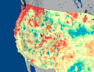
NASA researchers have developed new satellite-based, weekly global maps of soil moisture and groundwater wetness conditions and one to three-month U.S. forecasts of each product.
The projects aim to assess the current water use trends, identify and map out the key stakeholders, shared water-related risks, challenges and opportunity at the site and catchment level,…
Managed aquifer recharge (MAR) represents a viable method for sustainable water management. This viewer provides a global overview of MAR suitability maps and MAR case studies and their relevant…
Indicators of Hydrologic Alteration (IHA) is a software program that allows water resource managers, hydrologists, ecologists, researchers and policy makers to assess how rivers, lakes and groundwater basins have…
The Groundwater Exchange is an online resource center connecting water managers, water users, and community members with tools and resources to support the design and implementation of effective Groundwater…
This report is aimed at helping California’s water managers, public water agencies, county commissioners, city planners, and others better understand the suite of tools and approaches that can be…
Volkswagen partnered with Comisión Nacional de Áreas Naturales Protegidas and local stakeholders to restore the functionality of the ecosystems on the volcanic slopes of Popocatépetl and Iztaccíhuatl in order…
This website uses cookies to improve your experience. We'll assume you're ok with this, but you can opt-out if you wish. Cookie settingsACCEPT
Privacy & Cookies Policy
Privacy Overview
This website uses cookies to improve your experience while you navigate through the website. Out of these cookies, the cookies that are categorized as necessary are stored on your browser as they are essential for the working of basic functionalities of the website. We also use third-party cookies that help us analyze and understand how you use this website. These cookies will be stored in your browser only with your consent. You also have the option to opt-out of these cookies. But opting out of some of these cookies may have an effect on your browsing experience.
Necessary cookies are absolutely essential for the website to function properly. This category only includes cookies that ensures basic functionalities and security features of the website. These cookies do not store any personal information.
Any cookies that may not be particularly necessary for the website to function and is used specifically to collect user personal data via analytics, ads, other embedded contents are termed as non-necessary cookies. It is mandatory to procure user consent prior to running these cookies on your website.